


ARUtility app for iPhone and iPad
Developer: ARUtility LLC
First release : 09 Jan 2020
App size: 354.91 Mb
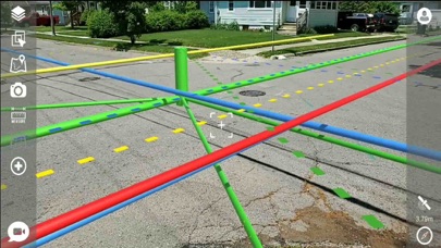
ARUtility is an augmented reality utility locating solution that allows users to see where utilities are located above and below the ground surface. Our mission is to create a safer work site, a more efficient worksite and help utilities better manage their assets.
Maintain a safe work site by allowing Engineers, Contractors, Inspectors and more to maintain a constant visual of where utilities are located. If physical markings are removed during construction you can maintain a visual of where utilities are located under the ground surface using our augmented reality solution.
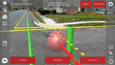
Utilities are able to better manage their assets using our augmented reality solution. Users are able to update GIS information on the fly. See an underground asset that is not correct in the GIS? Simply select the asset and update its location information by pointing the device at its real world location, ensuring the physical world is correctly represented in your GIS.
Utilities are also able to add new assets to their GIS system. No longer are you required to perform hand sketches for as-builts. Simply draw the new assets in augmented reality by pointing the device at the assets real world locations. All from the safety of the sidewalk.
Perform remote assistance and get answers out to the field in a more efficient manner. Allow office staff to remotely view your screen, including the augmented reality assets. Now youre able to communicate via voice and video with the help of augmented reality tools built into the conferencing solution. Office staff and field staff are able to draw on the screen and leave drawings and notes that stick in the real world.